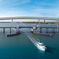
 High span to replace drawbridge at south end of island
STORY BY GEORGE ANDREASSI
Photo: Drone illustration shows new span with a clearance of 85 feet that will be erected over Intracoastal at south end of the island to replace old drawbridge.
Big changes are coming to the southern end of the island that will end drawbridge delays for 32963 residents who drive down A1A when headed for Fort Pierce, Stuart and points south.
The Florida Department of Transportation has finalized plans to replace the nearly 60-year-old drawbridge that now connects North Hutchinson Island – as the southern end of our island is known – to the Fort Pierce mainland.
Construction is set to start in January 2022 on a 4,150-foot-long concrete arch that will soar far above the Intracoastal Waterway navigation channel. The project is expected to be completed by early 2025.
The St. Lucie County Transportation Planning Organization voted unanimously this month to approve the design for the $70 million North Causeway Bridge replacement.
The new span, which will have a clearance of 85 feet for boats in the channel, will replace a steel and concrete drawbridge built in 1963 that has a clearance of 26 feet when the bridge is down. FDOT considers the drawbridge “structurally and functionally deficient.”
The new bridge will have 7-foot-wide bicycle lanes and 12-foot-wide traffic lanes in both directions. It also will have a 10-foot-wide multi-use path on the north side and an 8-foot-wide sidewalk on the south side.
There will be a 300-foot-long observation deck below the west end of the bridge, extending out over the water.
Instead of dipping down to the railroad tracks at Dixie Highway and then going up steeply to U.S. 1, as the bridge roadway does now, the new bridge will begin close to U.S. 1 and fly over the tracks and Dixie Highway.
In addition, FDOT will rework roads and ramps at both ends of the new bridge and build a new access road to North Causeway Island Park.
An average of 8,100 vehicles cross the North Causeway Bridge each day, FDOT records show. The old bridge will remain in service until the new bridge is complete.
Subsequently, 27 miles north at the other end of Vero’s barrier island, FDOT is planning to replace the 55-year-old Sebastian Inlet Bridge that links Indian River and Brevard counties.
FDOT is conducting an engineering study to determine how to build the new bridge while accommodating an average of 3,125 vehicles per day and allowing clearance for boat traffic during construction.
Plans call for construction to begin on the $50 million replacement bridge no sooner than 2026, depending on funding, records show.
A third bridge project is slated to begin next week in the heart of Vero Beach when long-awaited repairs to the Alma Lee Loy Bridge get underway on Monday, May 4.
FDOT anticipates spending $1.1 million to repair damage Hurricane Irma inflicted on the light poles, guard rails and walls of the 40-year-old concrete bridge in September 2017.
“I think it should’ve been renovated sooner,” said Ann Marie McCrystal, a longtime Vero Beach civic activist. “It’s too bad it didn’t happen in the lifetime of our dear friend Alma Lee Loy, whose name it bears, so she could see the refurbishing of the bridge.”
Loy, 90, a pioneering businesswoman and longtime civic leader in Vero Beach, died April 10 after a lifetime of service to the community.
FDOT has posted electronic signs at the span, also known as the 17th Street Bridge, warning motorists about the impending construction. An average of 20,500 vehicles cross the bridge each day, FDOT records show.
Workers may close lanes during off-peak hours to facilitate the repairs to the walls and installation of new LED lighting and guardrails. The project is due to be completed in the fall.
“I guess all you can say is, ‘Better late than never,’” said Kent Seeley, another Vero Beach civic activist concerned about the bridge. “It’ll be nice when it’s done. Hopefully, it’ll be safer at night, especially for people riding bikes and walking [when new lights are installed].”


